DEVELOPMENT PLAN #93 — Rivers Rise, Springs Run Dry: Water Sources That Remember the Weather
Contributed by: Takeshi Miyaoka on Tuesday, November 10 2026
Last modified on Tuesday, November 10 2026
This is a development plan: it describes something I would like to build next. None of what follows is implemented yet, and the details are still under consideration and may change before implementation.
In Ashwind Chronicle every region has its own weather each day, and the calendar panel shows today's weather. But the weather only matters on the day it happens. However many weeks of clear skies or days of steady rain pass, nothing builds up. Tonight's plan is to let each region's water source (a river, springs and rain, reservoirs and canals) decide how the same run of weather turns into drought or high water. I have filed it as a new improvement item, EVT-046. 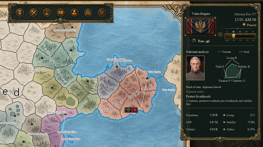
The actual Debug build screen (weather set to Rain through the verification procedure). The calendar panel at the top right shows today's weather and its strength in the capital region. Nothing about water sources or water reserves is shown today.
Where things stand: the weather changes daily, but nothing accumulatesThe weather is one of six types (clear, cloudy, rain, snow, fog, stormy) with a strength from 0 to 1. It is decided in the midnight daily update from a probability table for the season and climate zone (temperate, arid, oceanic, cold, mountain) and the previous day's weather, and recalculating the same day gives the same result. Only the latest two days are saved. Connecting the weather to production, roads, sea routes and air routes is waiting in line as improvement item EVT-041 (I described that plan in #85).
Meanwhile, with today's (November 10) master data update, every one of the 38 regions now has a water source value: springs and rain in 27, river basin in 4, coastal in 3, reservoir and canals in 2, and lake in 2. Right now those values are only used by the master data diagnostics that check neighbouring regions for contradictions, and the specification says they are not used in daily or monthly calculations. They do not appear on any game screen either.
What I want to make interestingA summer dry spell should hurt a village that collects rainwater differently from a town on a great river. And when the rain goes on and on, the river towns are the first to flood. I would like the water sources we defined region by region to become something you think about when deciding where to expand farmland and where to keep food in reserve.
Idea 1: one water reserve per regionEach region would keep a single water reserve from 0 to 100, normally sitting at 60. Right after the daily weather update, the day's weather moves it: rain raises it by strength (for example rain +6 × strength, stormy +9 × strength), and clear days lower it depending on season and climate zone (about -2.4 per day in a temperate summer, less in spring and autumn, very little in winter).
Each water source then puts its own twist on that change:
- Springs and rain: rain and drought hit at full force, the reserve recovers slowly, and it is the first to dry out in a clear spell.
- River basin: upstream flow keeps it from falling, but rain gathers from the whole basin, so it is the first to overflow in a long wet spell.
- Lake and reservoir and canals: gentle changes in both directions and a quick return to normal.
- Coastal: in between.
Below 25 the region would be in drought: farms, orchards, ranches and freshwater fishing lose up to 30% of their output depending on how deep the drought is, and crop failure becomes more likely. Above 85 in river basins and lakes it would be in high water: roads slow down (they never close) and fields take a little damage. 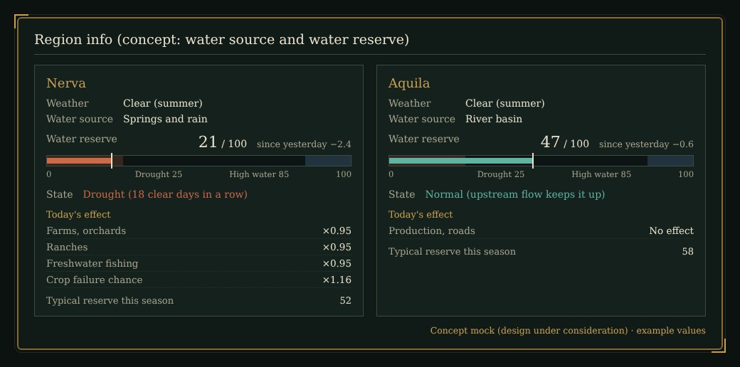
Concept mock (design under consideration). On the same clear summer day, Nerva (springs and rain) is in drought while Aquila (river basin) is normal. The numbers are examples.
Idea 2: same weather, different outcomesThe chart below feeds the same 60 days of weather (about 25 mostly clear days, then 10 days of rain and storms) to three water sources. Springs and rain drop into drought at the end of the dry spell; the river basin shrugs off the drought but climbs into the high-water band during the long rain; reservoirs and canals stay in the normal range throughout. 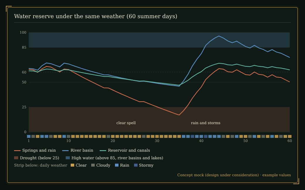
Concept mock (design under consideration). An example calculated with the starting values proposed above, not actual game values.
For players this should create regional reads such as "don't count on the rain-fed farms in summer" or "route supplies around the river provinces during the autumn rains". On screen, the region info would show the water source and water reserve (value, band, change since yesterday and the reason for drought or high water) under the weather, with a matching column in the region list.
Keeping it light, and never counting twiceThe water reserve stores one current value per region and no daily history. The update runs inside the midnight weather update, once per region (38 in all). Daily processing performance is what I am watching most closely right now, so there is no copying of the whole document and no rereading of history. Drought and high water would feed the same mechanism the weather and disasters use, where per-cause factors are multiplied together, under the cause "water", so the same loss is never counted twice. Like the weather, the update is deterministic: recalculating a day gives the same value.
Implementation order and related systemsThe prerequisite is EVT-041, which connects the weather to production, transport and air routes. After that, I am thinking of: (1) master data for the per-source factors, (2) the midnight update and saving of the water reserve (older saves start at the normal value), (3) the drought and high-water production factors, road effects and the link to crop failure chances, (4) display in region info and the region list (Japanese and English), and (5) checking with save/load round trips and the 31-day comparison. Using the water source in daily calculations changes an adopted specification, and the ticket says so explicitly.
This plan covers water sources only; the miasma influence values that entered the master data on the same day are not part of it.
Tell me what you thinkWould a numeric meter for drought and high water make planning easier, or would words like "a dry summer this year" carry more atmosphere? Does the idea that river towns are weak to long rains sound fun? Your comments help shape the design.
Image 1 was captured from the development Debug build with the verification procedure; images 2 and 3 are concept mocks (design under consideration). The numbers are examples, not actual game values.
This morning: DEVELOPMENT SNAPSHOT #92 — Trust Takes Shape: Officers Bring More Cards, or Fewer
The weather plan: DEVELOPMENT PLAN #85 — When the Weather Gets to Work: Rain, Snow and Fog on Farms, Roads and Skies
Previous plan: DEVELOPMENT PLAN #91 — Digging Floating Stones from Ruins: The Finite Relics Behind Every Airship
Check the download page for the currently published files and development status