DEVELOPMENT SNAPSHOT #106 — Freight in the Sky and at Sea: Airships and Ships on the Map
Contributed by: Takeshi Miyaoka on Tuesday, November 17 2026
Last modified on Tuesday, November 17 2026
State air cargo flights and port-to-port ships now move across the map. These two changes follow the trade wagons that already travel along the roads (pictured in evening post #105). The aim is to let you follow where a shipment is right now and when it will arrive on the map itself, instead of only in numbers and lists.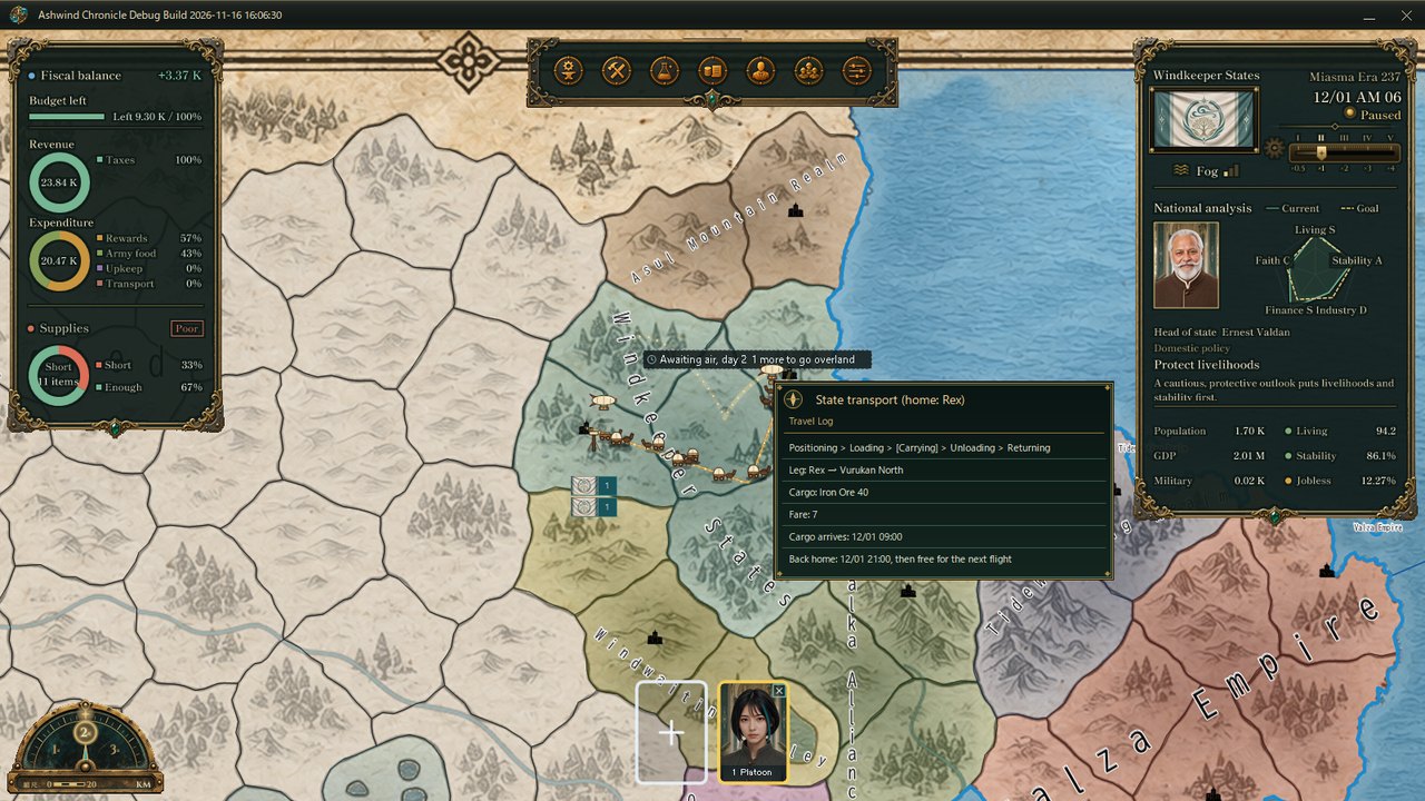
The travel log for a state transport aircraft (an actual screen from the Debug build). It lists the stages of the circuit, the leg, the cargo, the fare, when the cargo arrives and when the aircraft is back home; the current stage is in brackets.
1. Air freight: state transport circuits along arcs in the skyDock-to-dock air routes for state cargo (introduced in post #67) used to appear only in the booking list. Now each booked circuit sends an airship from its home dock to the origin province (positioning), on to the destination (the actual haul) and back home (returning), following an arc through the sky.
At the origin it picks up a slung crate and at the destination it sets it down, hovering low over the province while loading and unloading and casting a shadow on the ground. The haul leg is a gold arc with drifting specks of light; positioning and returning legs are faint dotted lines, and the mooring tower at the home dock blinks. Where cargo arrives, a ripple and a "delivered by air" label with the item and amount appear.
State cargo that is waiting because no aircraft is free gets a label at its origin: "Awaiting air, day n, m more to go overland". You can see on the map whether a shipment is still waiting for the sky or about to switch to the road.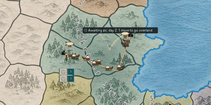
A closer view. The gold arc is the haul leg and the dotted line is the positioning leg; the awaiting-air label sits above, with trade wagons on the road below.
2. Sea freight: road to port, loading, voyage, unloading, road onwardCargo sent by sea is shown as a chain: wagons carry it to the loading port, it goes aboard, the ship sails the sea route, the cargo is unloaded at the landing port, and wagons take it on to its destination. Departure and arrival times are split across the land and sea legs using the same seasonal winds and currents that the route comparison already uses for ship speed.
Ships rock on the waves and leave a wake, their sails fill more with a tailwind, and streaks of the seasonal wind drift around them. The crane at the loading port swings while a "loading aboard" label is shown, and the lighthouse at the landing port turns its light while a ship is heading in. After delivery, ships sail back empty with their sails trimmed. Hover over a ship, or a wagon heading to the port, to see its travel log: stage, legs, voyage day, wind and speed, cargo, fare, and arrival times at the port and at the destination.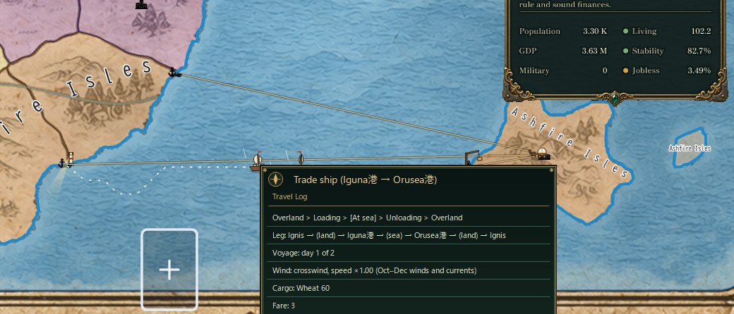
Mid-voyage between an island and the mainland. The trade ship's travel log shows the stages Overland > Loading > [At sea] > Unloading > Overland and a crosswind at speed ×1.00 for the October–December winds and currents. The port names in this capture still carry a leftover Japanese character (港, "port"), a gap in the English data I noticed while preparing this post.
3. Quiet when zoomed outWhen you zoom out to see the whole country, aircraft and ships are not drawn. Air freight is reduced to thin arcs for the haul legs, and sea routes are drawn thicker and brighter the more ships use them that day. Both run on the same clock and redraw mechanism as the wagons and rebuild their lists when bookings or waiting counts change. The seasonal wind and current directions were moved into a separate component, with no change to the values or the speed calculation.
What I checkedAutomated tests were added for circuit stages, cargo, direction and the provinces with waiting cargo, and for the order of ship stages, the land-leg endpoints and return voyages. Both changes went into main only after checking the movement and travel logs on actual Debug-build screens in Japanese and English. For ships between an island and the mainland in the same region, the land leg used to be drawn across the sea; that is fixed by deciding the loading and landing ports from the order of provinces on the route. Both changes are now with the user for on-screen review.
About the imagesAll images are actual game screens, captured on November 16 by starting the Debug build without showing its window, in a verification state started from the initial master data (images 2 and 3 are crops). Right at the start there are no real circuits or sailings yet, so verification flights and ships were placed for the captures. Nation and place names, items and amounts belong to the verification state.
How state air cargo works: DEVELOPMENT SNAPSHOT #67 — State Cargo Takes to the Air: Dock-to-Dock Routes and the Break-Even with Land
The idea of dangerous trade routes: DEVELOPMENT PLAN #105 — Bandits on the Road: When Trade Routes Turn Dangerous
Check the files currently available and the development status on the download page