DEVELOPMENT PLAN #85 — When the Weather Gets to Work: Rain, Snow and Fog on Farms, Roads and Skies
Contributed by: Takeshi Miyaoka on Friday, November 06 2026
Last modified on Friday, November 06 2026
This is a development plan article about something we would like to build next. Nothing described here is implemented yet; the ideas are still under consideration and may change before they are built.
Every day in the world of Ashwind Chronicle, rain falls somewhere, fog rolls in, and snow settles on the winter highlands. With today's work, that weather now also appears in the Region Information header and in the region list. For now, though, the weather is only something to look at: it does nothing to a farm's harvest or a wagon's pace. Tonight we look at an idea for letting weather affect production, transport and air routes, and for making those effects readable on screen. It builds on the existing improvement item EVT-041, and the ideas have been added to that ticket.
Where things stand: weather is decided every day, but affects nothing yetAt 0:00 every day, each region's weather is set to one of six types — Clear, Cloudy, Rain, Snow, Fog or Stormy — with an intensity from 0.2 to 1.0 (Clear is always 0). Regions have climate zones such as Arid, Temperate, Oceanic and Mountain, and the weather is chosen deterministically from seasonal probability tables plus a weight that carries over the previous day, so the same save always produces the same weather. The capital's weather is shown under the flag on the calendar, and since today's change the day's weather (type and Weak/Moderate/Strong) also appears at the right end of the Region Information header and in the region list. The image below shows the calendar. 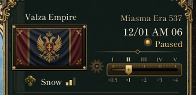
Image 1: the calendar at the top right of the map in a development debug build (development version of November 5), captured with the verification procedure on the first day of a new game. Under the flag is the capital's weather, "Snow", with its strength marker.
The "effects" part of the specification, however, is not connected yet. Production is the same in rain or sun, and land and sea routes move at the same speed. The weather intensity used for aircraft wear on air routes is still a fixed value set per route. The weather is visible, but it does not tell you what to watch out for.
What we want to make more interestingOnce weather means something, preparing for the seasons becomes part of play: "send extra to the warehouse beyond the mountains before winter", or "the autumn sea gets rough, so expect a shortfall from the fish farms". Because there is always some weather, we want its effects to stay within everyday bounds. Damaging facilities or reducing population and stockpiles remains the job of natural disasters (#61).
Idea 1: factors for production, land routes and sea routesEach weather type would have a maximum loss rate, multiplied by the day's intensity to give a factor: factor = 1 − maximum loss rate × intensity. On a day of snow at intensity 0.60, for example:
- Production: farms and orchards 0.82, ranches 0.91, fish farms and freshwater fishing 0.88, forestry and mining 0.85. These combine with disaster multipliers by multiplication. In periods with no production, such as the winter fallow, nothing is listed in the breakdown.
- Land routes: speed 0.79, capacity 0.91. When a leg spans two regions, the worse weather applies.
- Sea routes: speed 0.94. Fog and storms are harder on the sea; fog at intensity 0.80 gives a speed of 0.76.
No weather closes a route. Cargo already under way keeps its route, and only its expected arrival is updated. In a region hit by a storm disaster, the weather route factor stays neutral so the same storm is not counted twice. 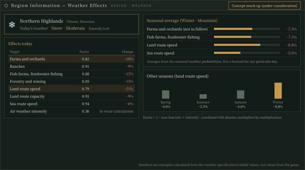
Concept mock-up (under consideration). Numbers are examples calculated from the weather specification's initial values, not values from the game.
Idea 2: air routes follow the day's weatherWe would like air route weather intensity to come from the day's weather in the departure, arrival and en-route regions, and to feed it into the existing aircraft weather resistance and wear calculation. The conversion is intensity multiplied by 0.3 for rain, 0.6 for snow, 0.4 for fog and 1.0 for storms. While a route still has its fixed value, the larger of the two applies. On days with fog of intensity 0.7 or more at the departure or arrival region, new flight bookings would be deferred to the next day; flights already in the air would continue.
Idea 3: making the effects readableEffects alone do not explain why a harvest fell or a shipment ran late. So beside the weather in Region Information we would list today's effects, a factor for each target, along with the typical effect for this season. The seasonal figure is a fixed value derived from the probability tables and average intensity, not a forecast that rolls dice for a particular day. With the specification's initial values, temperate farms lose about 2% on average from spring to autumn, oceanic fish farms about 6.5% in autumn, and mountain land routes slow by about 9% in winter.
Transport estimates would also name "weather" as the cause, with the weather on that leg, and show how many days of delay to expect. Seeing today's effects next to the seasonal average should make it possible to notice that "this winter is rougher than usual". 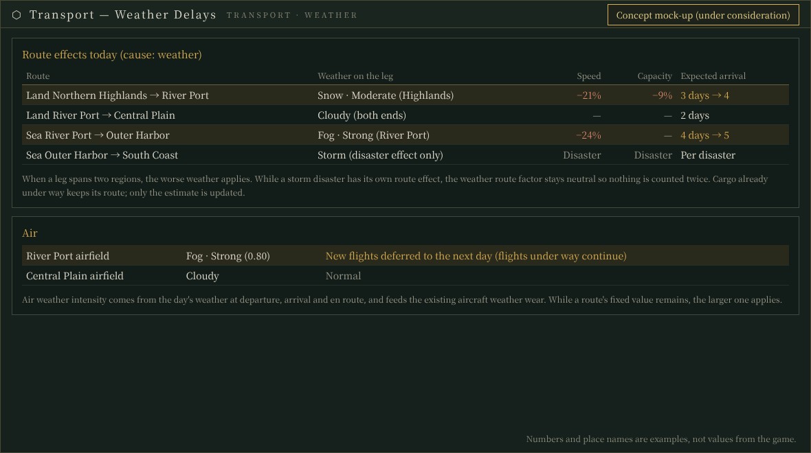
Concept mock-up (under consideration). Numbers and place names are examples, not values from the game.
Implementation steps and how it connects to other systemsThe planned order is: (1) put the per-type effect table in the master data and rebuild the effects at 0:00 each day, (2) connect production multipliers, (3) connect land and sea route effects (revising the previous day's entries rather than rebuilding them all), (4) air route intensity and fog deferral, (5) the Region Information and transport estimate displays (Japanese and English), and (6) nightly 31-day comparisons, save/load round trips and a recheck of the pre-start operating history. Because the effects change quantities, performance and quantity checks will be done carefully in the nightly runs.
Since the fixed per-route weather intensity is eventually removed, this item changes an adopted air route specification. The production factors ride on the same multiplication as natural disasters (#61), and transport delays should become one more input when reading the supply outlook (#79) and the supply window below the overview (#78).
Tell us what you thinkDo effects "within everyday bounds" — a few percent on average — feel right, or would clearer swings, such as snow closing a mountain pass for a few days, be more fun? And would a seasonal average help you decide how to prepare? We would love to hear your thoughts.
Image 1 was captured from a development debug build with the verification procedure; images 2 and 3 are concept mock-ups (under consideration). Numbers are examples, not values from the game.
This morning: DEVELOPMENT SNAPSHOT #84 — Taxes Join Domestic Affairs: A Tax Plan You Can Delegate
How the calendar shows weather: DEVELOPMENT SNAPSHOT #59 — The Calendar Keeps Up: Reading Today’s Weather Before It Is Confirmed
Disasters and harvests: DEVELOPMENT SNAPSHOT #61 — Different Harvests Under the Same Disaster: When Crop Failure Meets Insects
Previous plan: DEVELOPMENT PLAN #83 — The Ruler's Charge: Quarterly Goals from the Head of State
See the files currently available and the development status on the download page