
DEVELOPMENT PLAN #109 — A Town Inside the Regional Capital: Hex Streets and Gates
- Wednesday, November 18 2026
- Contributed by: Takeshi Miyaoka
- Views: 21
This is a development plan: it describes something we would like to build next. None of it is implemented yet, and the details are still under consideration and may change before they are.
Tonight's idea is to build a town inside each regional capital on the map. Clicking a capital's icon would open a town map made of hexagonal tiles (hexes), where you decide where the castle, housing, market, wells, workshops, fields, roads, walls, gates and bridges go. The aim is for the layout of roads and gates to matter twice: for how convenient daily life and logistics are, and for how easy the town is to defend when an enemy arrives. It is registered as improvement item WLD-019 (a hex town in the regional capital, with layout effects on living, logistics and ground defense), and the specification for its first stage was written up today. 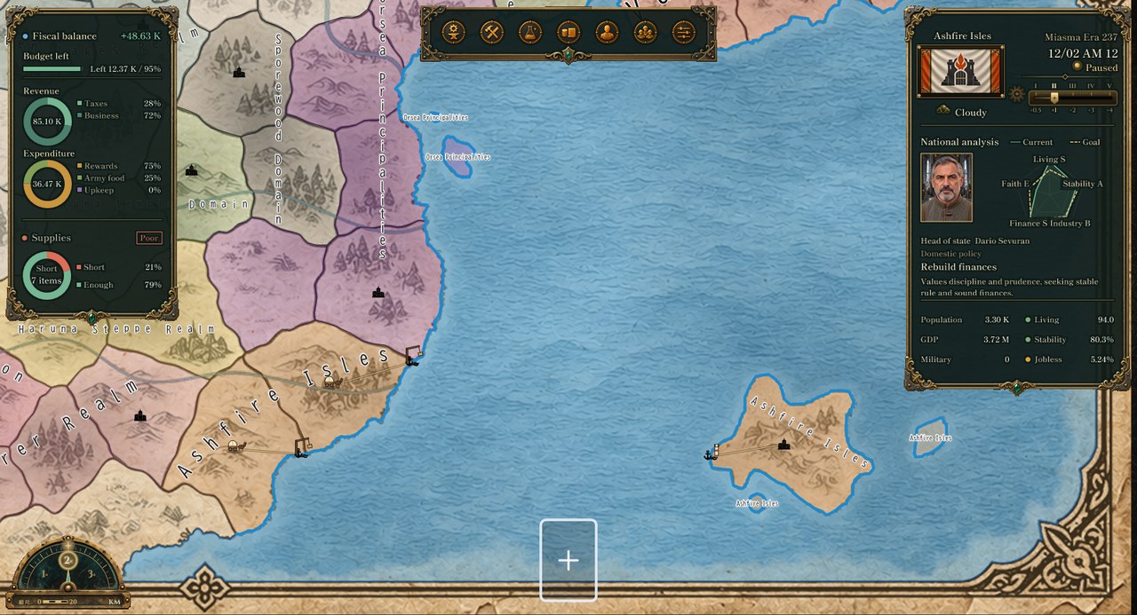
The map today (an actual screen of the Debug build, from a verification state, a new game started from the initial master data and advanced a few days, captured off-screen on November 18 to check the ship display, UI-085; window title removed and scaled down). The black castle icon in each region marks its regional capital. There is no town inside it yet.
Where things stand- The map draws a castle icon at the position of each region's capital. There is no information about which buildings stand inside the capital, or how they are arranged.
- Facilities are held per province as counts, by facility type and by ownership (private or state). There is no position for where each facility stands. Population is likewise held per province as head counts for each economic class (upper, middle, lower).
- In a battle in a province, the combat width (how much can line up at the front) comes from the province's terrain: plains 48, hills 36, forest 32, urban 28, and urban terrain carries a +30% defense modifier.
- The battle calculation already has a way to split the attacker into several "attack routes": a route that has no defender for three rounds in a row breaks through. In the actual game, however, a province battle currently uses a single attack route.
In short, the shape of a regional capital shows up neither in the economy nor in battle.
The plan: a town map that opens from the capital iconThe WLD-019 specification (stage 1) describes the following.
- Clicking a capital icon on the map opens a child window, "Regional Capital: {name}". The town map is 16 rows by 16 columns of hexes; about 8 by 8 is visible at first, and you drag to move around.
- The castle sits in the middle. Roads run out from it, with upper-, middle- and lower-class housing, a market and wells around it, and workshops and fields spreading beyond the wall. The terrain (plains, hills, forest, mountains, river, sea, wasteland) decides what can be built where; fields only on plains, for example, and only bridges on a river.
- Every facility fits in exactly one hex. Roads use a single all-cobblestone tile that connects to a neighbouring road in any of the six directions. Walls are single-hex blocks with crenellations, and wherever a road passes through the wall, that hex becomes a gate.
- The town map is only a ledger of which facility or house is where. Facility counts and population stay as they are today and remain the source of truth; the map never holds a second copy of them. When construction finishes and a count goes up, the new facility waits for a place, and you choose a hex for it. The number of housing hexes comes from the population, with one hex thought of as a cluster of about 2,000 people.
- In a new game, the first town is assembled by a fixed procedure: terrain, castle, roads, wall, housing, facilities. The same province always produces the same town.
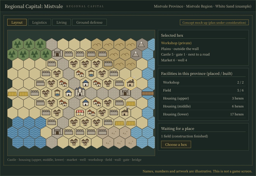
Concept mock-up (plan under consideration). The capital's town map, with the selected hex, the province's facilities (placed versus built), and the facilities waiting for a place. Names, numbers and artwork are illustrative; this is not a game screen.
The plan: every gate is a way inFrom here on, these are new ideas from tonight's article for how the layout effects could be calculated (input for stages 4 and 5 of the specification, where those numbers are decided).
- When a battle takes place in the capital's province, we would like the number of attack routes to equal the number of gates through which the castle can be reached from outside (capped at around three). In the existing battle rules, defenders are redeployed to the attack routes that can still fight, and a route with no defender moves toward a breakthrough. More gates make it easier for people and goods to come and go, but also leave more ways in to guard.
- We would like the number of rounds needed to break through each route to depend on the road distance from the gate to the castle; for example, 3 + (distance − 4) ÷ 2, rounded down. A straight avenue to the castle keeps it at 3 rounds; winding streets that make the distance 8 raise it to 5.
- We would like a route through a gate to have half the combat width of the province's terrain, and a route over a bridge to be narrower still (on plains, 48 becomes 24 at a gate and 16.8 on a bridge, as a first idea).
- Each hex costs some effort to cross: 1 for a road, gate or bridge, 2 for plains, 3 for hills or wasteland, 4 for forest. Walls can only be crossed at a gate. The way with the least total effort is the one that counts.
- The effort from a workshop to the market or a gate would affect work and transport efficiency, and the effort from housing to a well or the market would affect how convenient life is.
- This is calculated only when the layout changes, and the result is stored on the town map. It is not recalculated in the daily midnight processing.
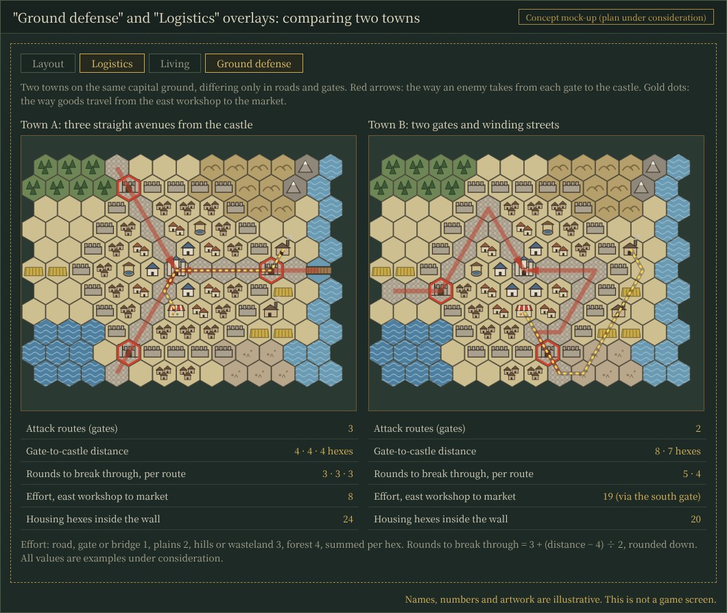
Concept mock-up (plan under consideration). Two towns on the same ground, differing only in roads and gates, compared with the "Ground defense" and "Logistics" overlays. Names, numbers and artwork are illustrative.
Comparing the two towns in the mock-up: Town A runs three straight avenues out from the castle and has three gates. Every gate is 4 hexes from the castle, so each route needs 3 rounds to break through. The effort from the east workshop to the market is 8. Town B keeps only two gates and bends the streets inside the wall. There are now two attack routes, 8 and 7 hexes from the castle, needing 5 and 4 rounds. In exchange, with the east gate gone, goods from the east workshop take a detour through the south gate, and the effort rises to 19. The winding streets also take up space, so housing inside the wall drops from 24 to 20 hexes (all numbers are examples from the mock-up, not calibrated values). We would like the choice between a town that is easy to defend and one that is convenient and roomy to come out of the layout itself.
Implementation steps, and how it fits with other systems- Specification and icon images (stage 1, written today and awaiting review).
- A display-only town map: assembling the first town, the child window, dragging, the selected hex, saving and reloading, and opening older saves.
- Editing the layout: choosing a hex for a construction order, the cost and time of moving or removing, and facilities waiting for a place, without counting anything twice against construction orders or the budget.
- Living and logistics effects (considering the "effort" idea above).
- Ground defense: walls, gates, bridges and roads feeding into the attack routes, combat width and defense of the province battle (no new kind of battle).
- The "Logistics", "Living" and "Ground defense" overlays, and a preview before building.
- Layouts for AI nations, and a full check.
Towns in provinces with a port, and the placement of anti-aircraft guns (how much of the castle, workshops and port they can cover), would follow in later stages. This connects to the facility screen and construction orders (#104), and it would be the first place where the battle system's multiple attack routes are used in actual province battles.
Tell us what you thinkIf you could lay out your regional capital yourself, how much detail would you want to handle? Does choosing between more gates for convenience and fewer gates for defense sound like something you would enjoy? We would also like to hear about further directions, such as fields and workshops outside the wall being easier to raid, or a bridge over the river becoming a key point.
About the imagesImage 1 is an actual game screen from a verification state, captured off-screen from the Debug build on November 18 while checking the ship display (UI-085). Images 2 and 3 are mock-ups to explain the plan, not game screens. The town artwork in them is a simple drawing made for the mock-up, not the images the game will use.
Related articles: DEVELOPMENT SNAPSHOT #104 — Facilities at a Nationwide Glance: One List, Queue Cards, Named Houses, DEVELOPMENT PLAN #101 — The Enemy of My Enemy: Sharing a Battlefield Across Separate Wars, DEVELOPMENT PLAN #97 — Breaking the Air-Defense Net from Within: Sabotage and Ammunition Stores
Check the files currently available and the development status on the downloads page